|
|
|
In May 2011 I did a four day trek along the Inca Trail in Peru with Geckos Adventures. The trek goes over high passes, through different vegetation zones and past many Inca ruins on the eastern side of the Andes, culminating in Machu Picchu. A selection of photographs from this trip is contained below. Click on the thumbnails to see larger images:
|
|
|
||
|
|
I arrived in Cuzco the day before the trek started and spent some time wandering the streets looking at the Inca stonework and colonial buildings throughout the city. |
||
|
|
|
||
|
|
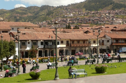
The Plaza de Armas in the centre of Cuzco is a popular place for tourists and locals. The Plaza is surrounded by churches and cathedrals and many tourist shops and markets. |
||
|
|
|
||
|
|
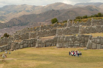
Above the city is the Inca fort of Sacsayhuaman, which consists of three huge zig-zag walls built of massive stones. This is also the site of the Inti Raymi festival which I had attended on my previous visit here. |
||
|
|
|
||
|
|
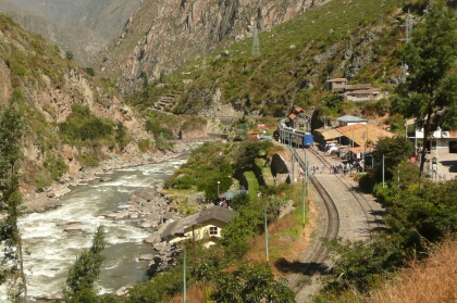
The following morning our group was driven to Ollantaytambo then further down the valley to Kilometre 82, which is the official start of the Inca Trail. This is located on the railway line to Machu Picchu and next to the Urubamba River. We unpacked our gear, met our porters, had our paperwork checked then we were on our way. |
||
|
|
|
||
|
|
The suspension bridge over the Urubamba River marks the start of the Inca Trail. |
||
|
|
|
||
|
|
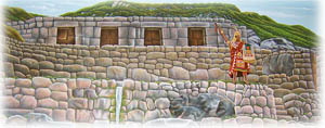
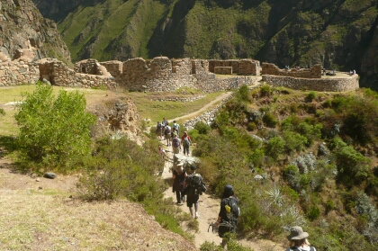
After an hour's walking we came across our first Inca ruins. |
||
|
|
|
||
|
|
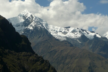
Mt Veronica, which is 5750m high, looms above the Urubamba River and is visible for most of the first day of the trek. |
||
|
|
|
||
|
|
Llactapata is a large Inca agricultural site near the junction of the Cusichaca and Urubamba Rivers that supplied food for Machu Picchu and the surrounding area.. |
||
|
|
|
||
|
|
The Inca hillfort of Huillca Raccay is situated overlooking the Cusichaca River valley and the Llactapata ruins. |
||
|
|
|
||
|
|
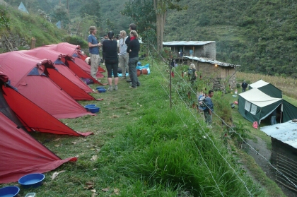
At the end of the first day we camped just above the village of Wayllabamba at an altitude of 3200m. The first day was fairly easy with not much altitude gain, but it would be different the following day. |
||
|
|
|
||
|
|
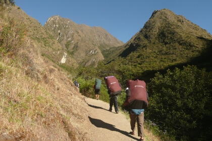
The next day we began the long climb up to Warmiwanusca (Dead Woman's) Pass. |
||
|
|
|
||
|
|
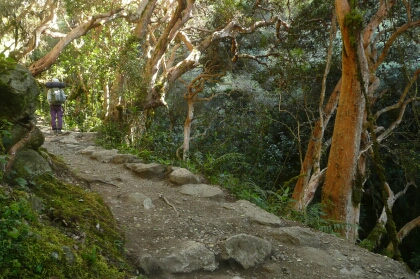
Along the way we passed through a picturesque section of cloud forest with twisted trees. |
||
|
|
|
||
|
|
The trail above the village of Llulluchapampa. From here the altitude started taking effect and it was a long, slow climb to the pass. |
||
|
|
|
||
|
|
Warmiwanusca Pass at 4215m. This was the highest point on the trek and beyond here the trail became easier, although more rocky. |
||
|
|
|
||
|
|
Our group photograph at Warmiwanusca Pass. From here we had a 600m descent to the campsite in the Pacamayo Valley. |
||
|
|
|
||
|
|
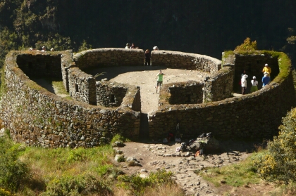
On the third day of the trek we passed many Inca sites, including the ruins of Runkurakay. This circular building high above the Pacamayo River is thought to have been a resting place or guard post. |
||
|
|
|
||
|
|
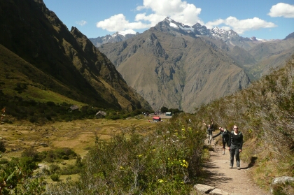
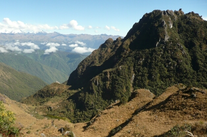
We climbed to a second pass at 3950m from where we had views of the snow-covered Vilcabamba Range. The vegetation became thicker beyond here as we entered the cloud forest region. |
||
|
|
|
||
|
|
The ruins of Sayaqmarka are perched on a rocky promontory above the cloud forest and Aobamba River valley. |
||
|
|
|
||
|
|
The ruins at Sayqmarka. |
||
|
|
|
||
|
|
The trail passes through a 16m long tunnel carved out of the rock by the Incas. |
||
|
|
|
||
|
|
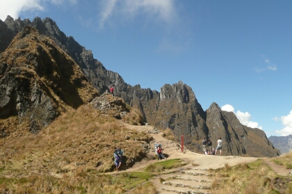
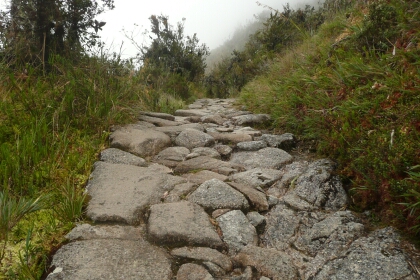
A typical view of the Inca Trail on the third day of the trek. The trail was very rocky and you had to be careful where you put your feet. |
||
|
|
|
||
|
|
We had lunch at the third pass just above the ruins of Phuyupatamarka. The amazing views from here were obscured by cloud. |
||
|
|
|
||
|
|
Phuyupatamarka (Cloud-Level Town) is an Inca site at 3600m high above the Urubamba River. From here we had our first view of Machu Picchu Mountain. |
||
|
|
|
||
|
|
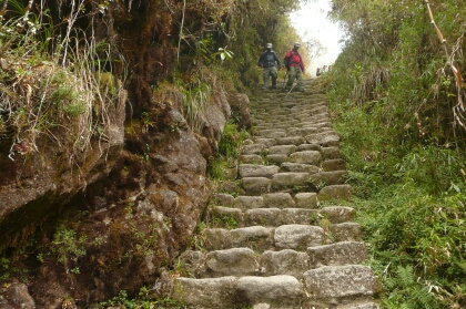
From Phuyupatamarka we descended for about two hours down a flight of Inca steps through beautiful cloud forest. |
||
|
|
|
||
|
|
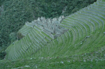
Intipata was an agricultural settlement and consists of extensive terraces on a steep slope high above the Urubamba River. |
||
|
|
|
||
|
|
Winay Wayna is an impressive Inca ruin located next to the Trekkers Hut and final campsite. |
||
|
|
|
||
|
|
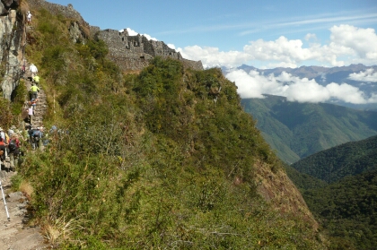
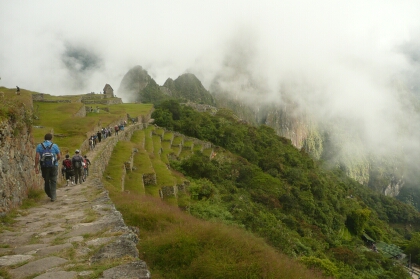
Walking into Machu Picchu at the end of the Inca Trail. We left the campsite at 5:30am and walked for 1.5 hours to Intipunku, the Sun Gate, to see the sunrise on the Machu Picchu ruins, however it was foggy and we didn't see a thing. By the time we arrived at Machu Picchu the fog began to lift. |
||
|
|
|
||
|
|
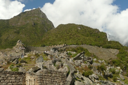
Machu Picchu ruins and Huayna Picchu peak. This was my second visit to the ruins following my previous visit in 1997 when I arrived by train. |
||
|
|
|
||
|
|
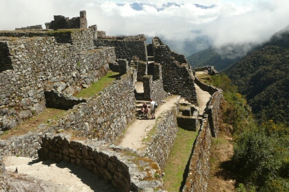
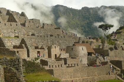
Inca buildings at Machu Picchu. We had a two hour guided tour of the site with our trekking guide then free time afterwards to explore the ruins further. |
||
|
|
|
||
|
|
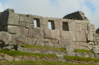
The Temple of the Three Windows. |
||
|
|
|
||
|
|
Terraces and temples at Machu Picchu. |
||
|
|
|
||
|
|
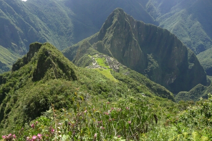
Machu Picchu Mountain looms 500m above the ruins of Machu Picchu. I decided to climb this peak, which is higher but less crowded than the Huayna Picchu climb. |
||
|
|
|
||
|
|
As the trail climbs higher the views of Machu Picchu become more spectacular. |
||
|
|
|
||
|
|
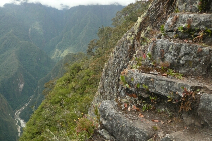
The trail towards the top of the Machu Picchu Mountain is steep and very exposed. It took about 1.5 hours to reach the top. |
||
|
|
|
||
|
|
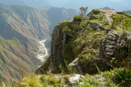
From the summit of Machu Picchu Mountain there is a sheer 1000m drop to the Urubamba River below. This is one of the most exhilarating places I have been to due to the 360 degree views and the exposure. |
||
|
|
|
||
|
|
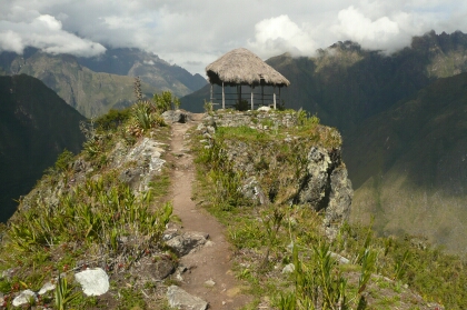
There is a small rest hut on the narrow ridge at the top of the mountain. |
||
|
|
|
||
|
|
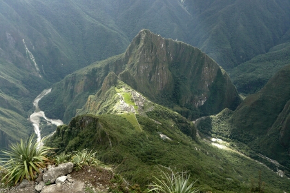
Looking down to Machu Picchu from the top of Machu Picchu Mountain. There was a great view of the ruins and the Urubamba River encircling Huayna Picchu mountain. |
||
|
|
|
||
|
|
Machu Picchu Mountain from near the Inca Bridge. |
||
|
|
|
||
|
|
The Inca Bridge is located on a sheer rockface near the ruins, and contained a drawbridge that could be removed if needed. |
||
|
|
|
||
|
|
Machu Picchu in the late afternoon sun. By this time many of the crowds had gone and we could enjoy the ruins in solitude. We then descended to Aguas Calientes and caught an evening train back to Cuzco. |
||
|
|
|
|
|


![]() Contact "alanlevy at pcug dot org dot
au" for more information.
Contact "alanlevy at pcug dot org dot
au" for more information.
View my other pages: [Home] [Antarctic Peninsula] [Antarctic Flight] [Shackleton Odyssey] [South Georgia] [Easter Island] [Southern Africa] [Galapagos Islands] [Australia] [China] [Egypt] [US & Canada National Parks] [Hawaii] [Cross Country Skiing Photographs] [The Kimberley] [The Himalayas] [Switzerland]
Related Links: [Geckos Adventures]
Page last modified on